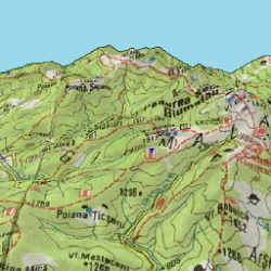
- ソフト名 :ElevMaps
- バージョン : 1.7.19
- カテゴリ :地図&ナビ
- Android 要件 : 4.0 以上
- 開発 : Home
- コンテンツのレーティング : 3 歳以上
ElevMaps詳細
3D map viewer for your hiking trips.
The 3D maps are rendered in OpenGL by combining map tiles from various sources with elevation data.
Do not expect too much from this app since I'm developing it in my free time. The user interface is poor and simplistic.
Current features:
• View online/offline maps in 3D;
• Download map areas for offline use;
• View offline maps downloaded with Mobile Atlas Creator (MOBAC) (atlas format: OSMAND tile storage);
• View Mapsforge maps;
• Import and view OziExplorer maps;
• Attach elevations for current downloaded maps;
• Track recording;
• Track builder;
• Track play;
• Import/Export of tracks in KML format;
• Statistics (altitude, speed, distance);
• Use elevation data in SRTM3 format. あなたのハイキング旅行のための3Dマップビューア。
3Dマップは、標高データを様々なソースからのマップタイルを組み合わせることにより、OpenGLでレンダリングされる。
私は私の自由な時間でそれを開発していますので、このアプリからあまり期待しないでください。ユーザーインターフェースが悪いと単純です。
現在の特徴:
3Dで•表示オンライン/オフラインのマップ。
オフラインで使用するため•ダウンロードマップ領域。
モバイルアトラスクリエイター(MOBAC)(アトラス形式:OSMANDタイルストレージ)と一緒にダウンロード•表示オフラインマップ。
•表示Mapsforgeマップ。
•インポートとマップをOziExplorer図である。
•現在のダウンロードマップの標高を取り付けます。
•トラック録音。
•トラックビルダー。
•トラックをプレイ。
•KML形式でトラックのインポート/エクスポート。
•統計(高度、速度、距離);
•SRTM3形式で使用する標高データ。